
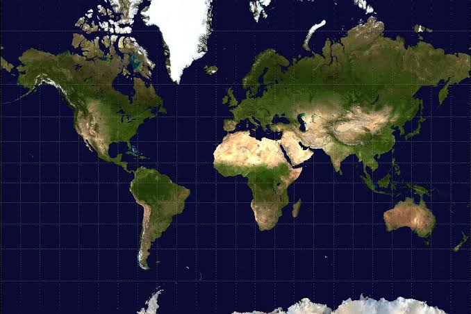
The United Nations General Assembly is due to vote on a resolution that would formally encourage the world to phase out the traditional Mercator map in favour of projections that more accurately show the true scale of Africa and other continents.
The draft resolution, tabled by Togo and backed by all 54 African Union member states, asks governments, schools, international organisations and technology companies to adopt the Equal Earth projection and other equal-area maps wherever accurate representation of landmass matters. It does not seek to ban the Mercator projection outright but aims to establish more proportionally accurate maps as a new global norm.
The vote is scheduled for Friday, September 4th, 2026, at the UN headquarters in New York.
For centuries, the Mercator projection, designed in 1569 for maritime navigation, has been the default world map in classrooms, textbooks, news media and digital platforms. Because of its design, it preserves angles and shapes but greatly distorts area, especially far from the equator. Regions near the poles appear much larger than they are, while equatorial regions look smaller.
On a Mercator map, Africa appears roughly similar in size to Greenland, even though the continent is about 14 times larger in reality. Africa’s actual land area is around 30.4 million square kilometres, compared with Greenland’s roughly 2.2 million square kilometres. The distortion also makes Europe and North America look disproportionately large relative to Africa, South America and other tropical regions.
Campaigners argue that this visual distortion has shaped perceptions of Africa’s importance, resources and geopolitical weight for generations. Togo’s foreign minister, Robert Dussey, who is leading the #CorrectTheMap campaign, has said the initiative is about “correcting a centuries-old error” and giving people a more honest view of the world.
After extensive research, the campaign settled on the Equal Earth projection, created in 2018 by an international team of cartographers. Equal Earth is an equal-area map, meaning it shows every landmass in its true relative size while still preserving a familiar, rectangular world map layout. It was designed specifically to address the distortions of older projections without sacrificing usability.
The UN draft resolution calls on member states and relevant actors to gradually replace Mercator-based world maps in education, public administration and official communications with equal-area alternatives such as Equal Earth, encourage technology companies and mapping services to offer equal-area options as defaults where accurate area representation is important, and support public awareness campaigns on map distortions and the true scale of continents.
UN General Assembly resolutions are non-binding and cannot force countries or companies to change their maps. However, if adopted, the resolution could carry significant symbolic and practical weight. It could prompt updates to school curricula, government publications, media graphics and digital mapping tools that currently rely heavily on the Mercator projection.
Supporters hope the vote will accelerate a shift already underway in some countries and institutions that have begun using equal-area maps to teach geography and present global data. Critics, including some cartographers, argue that no single projection is perfect and that different maps serve different purposes, but the campaign stresses that Equal Earth is intended for general reference, not specialised navigation or technical work.
If the resolution passes, the focus will move to implementation: how quickly ministries of education, international bodies and tech platforms integrate Equal Earth or similar projections into their materials. The campaign is relying on education, advocacy and peer pressure rather than legal enforcement to drive change.
For Africa, the initiative is as much about perception as cartography. By putting the continent’s true size front and centre, supporters believe the new map could help recalibrate how the world sees Africa’s role in global affairs, from climate negotiations to trade and security.
Africa Presents is a Pan-African digital magazine and monthly publication covering politics, business, economy, culture, tech, and the stories shaping Africa and its diaspora. Visit africapresents.com and follow @AfricaPresents for daily coverage and monthly themed magazine editions.




Leave a comment